In the previous post, I discovered a reasonable way to obtain aerial imagery, but it wasn’t supremely useful for sizing up properties (literally and figuratively). Houses would often list the parcel size (mostly a ballpark), but it was not at all apparent what shape that parcel was. Parcelling property also seems to be a relatively arbitrary process when it comes to the geography, prioritizing ease of surveying and recording over usefulness. For example, we looked at this property:

The listing said it was a certain size, I believe somewhere in the 4 acre range. Our experience was if you showed enough interest, you might be able to get a copy of the survey, or sometimes just a picture of a copy of the survey. Sometimes it was easier to just guess.
I’m not sure why you can’t make shapes on Google Maps directly, but we used DaftLogic’s area tool to try and find a ballpark. Unfortunately you’re left with a different image to play with, but you can still get a rough idea. Being optimists, we had hoped the property would looks something like this – it made sense and it was the right size:

Right? Underneath the very clear line of active agriculture, aligned with the trees to the North, almost exactly the right area. Surely it must be in the ballpark.
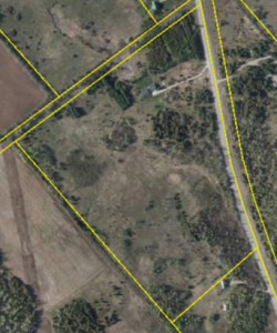
Only later, when introduced to GeoOttawa did we find out the actual parcel. Turns out GeoOttawa has an awesome overlay feature. One of those overlays is property parcels, which could not be more perfect. It also revealed the unfortunate truth:

So this property went from pretty compelling to pretty awful. The back section is cut off by a municipal drain, apparently the farmer to the North is using part of the property, and there is a ditch cutting the property in two – generally not a great parcel. Lesson being, going in armed with the actual property parcel can quickly eliminate duds.
Long story short, we were able to get the actual property parcel for our land!